Walking
Table of Contents
Walking is simple, free, and one of the easiest ways to get more active, lose weight and become healthier. It is good for you and good the planet too as it produces no carbon emissions and it lets you take in the beauty of the natural world around you. By switching to walking from other modes of transport, you are reducing your impact on the environment.
Myth buster: Did you know that you are actually more likely to be exposed to higher levels of air pollution when travelling in a vehicle than you are if you are walking or cycling.
NHS - walking and staying motivatedWhether you’d like to join a led walk over a short or long distance or just want to download a route to walk by yourself, you’ll find it below with information about walk programmes and walking routes.
If you get chance to do your walking in nature, it is a great way to relax and it can be good for your mental health. In South Gloucestershire we are blessed with many beautiful natural locations, and we are working hard to protect and restore nature.
This page is for information purposes only. Please note that all providers listed are independent of the Council and the Council takes no responsibility for their ability to provide the services they offer. Please ensure that you use the provider best suited to your needs and contact them if you require further information about their services.
Age UK South Gloucestershire walking programme
The Walking Well Programme is now being managed by Age UK South Gloucestershire (for adults aged 50 and over) instead of South Gloucestershire Council.
How to attend the walks
All Walking Well walks will continue at the same locations and times as the previous programme that was delivered by South Gloucestershire Council. You just need to turn up as usual and Age UK South Gloucestershire will complete the paperwork required with you. You do not need to book on via Eventbrite. Age UK South Gloucestershire will provide you with details if they would like to you to pre book in due course.
New walkers/more information
To find out more, you can contact: walking@ageuksouthglos.org.uk Call:01454 411707
What if I am under 50?
For further information about other led walking opportunities, please click here.
Age UK South Gloucestershire Walking Well walks
| Bristol & Bath Railway path
Every other Monday at 11am Location – Avon Valley Railway, Bitton Station, Bath Road, Bitton, BS30 6HD
|
Every other Monday at 11am |
| Bitton
Avon Valley Railway, Bitton Station, Bath Road, Bitton, England, BS30 6HD |
2nd Wed of the month at 2pm |
| Page Park (gentle walk)
Meet at Clocktower, Page Park, Park Road, Bristol, England, BS16 5LB |
Tuesdays 11.30am and Fridays 10.30am |
| Page Park
Meet at Clocktower, Page Park, Park Road, Bristol, England, BS16 5LB |
4th Wed of the month at 2pm |
| Thornbury
Middle of St Mary’s Centre Thornbury behind Savers, Quaker Lane, Thornbury, BS35 2AD |
Every other Tuesday 10am |
| Young Onset Dementia
Alternating between Kingsgate Park, Yate and Page Park, Staple Hill
|
2nd Friday of the month |
Leisure walks
Extended list of walking routes in South Gloucestershire
The below routes vary from short circular walks designed to be easily accessible, to long-distance walking routes.
Click on the menus below for a full list of walks in each area (all of the below are downloadable PDF leaflets except Frampton Cotterell which links to an external website):
Cotswold walks
Frome Valley walks
Frampton Cotterell
Jubilee Way walks
Severn way walks
Staple Hill walks
Warmley and Siston walks
Heritage trails
Within South Gloucestershire lie many hidden treasures that have helped shape the landscape as we know it today. Natural, industrial and cultural forces have played a part in making up the local environment that we live and work in.
A list of or heritage trails and links to the leaflets are below:
Heritage walks
-
- All around Avonmouth
- Avon Valley Woodlands heritage walks
- Bradley Stoke heritage walks
- Dramway
- Emersons Green heritage walks
- Frampton and Coalpit Heath
- Hatter’s trails – Frampton and Watley’s End
- Industrial places
- Lower Severn Vale levels
- Lower Severn Vale Levels – Hill hike
- Lower Severn Vale levels – Lamplighter’s walk
- Lower Severn Vale levels – Lawrence Weston Moor loop
- Lower Severn Vale levels – Little Littleton loop
- Lower Severn Vale Levels – Long Littleton loop
- Lower Severn Vale levels – Oldbury Kington loop
- Lower Severn Vale levels – Oldbury Outing
- Lower Severn Vale levels – Severn Beach short north
- Lower Severn Vale levels – Severn Beach short south
- Lower Severn Vale levels – Severn Beach stride
- Lower Severn Vale levels – Shire Stroll
- Lower Severn Vale levels – Spaniorum Skyway
- Lower Severn Vale levels – Two Bridges loop
- Lower Severn Vale levels – Wind bound wander
- Nonconformist trail
- Pucklechurch village
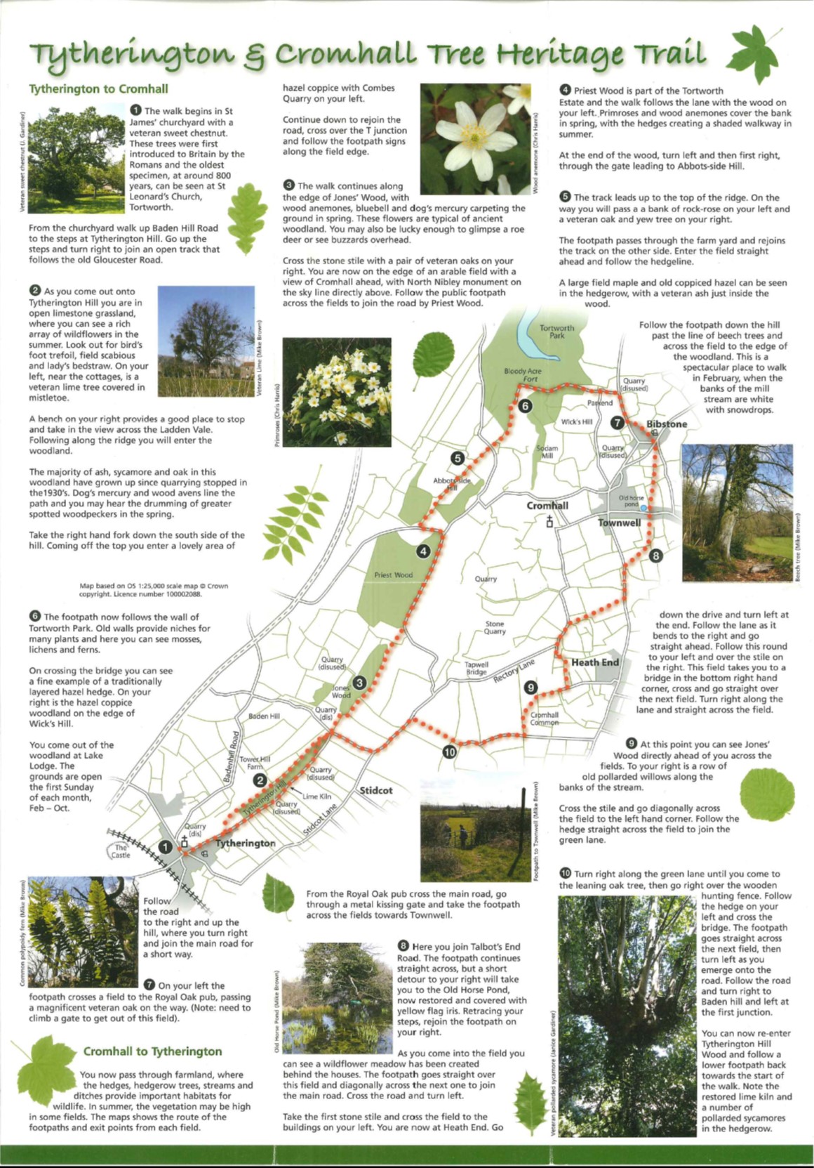
- Tytherington and Cromwall Tree Trail
- Tudor places trail
- Warmley Forest Park heritage walks
- Wick Golden Valley Walk
- Willsbridge Valley heritage walk
The Monarch’s Way
The Monarch’s Way traces the 579 mile route of taken by King Charles II after his defeat and escape from Cromwell in the final battle of the Civil War in 1651. It passes through South Gloucestershire from Chipping Sodbury, on through Pucklechurch and Wick to the river Avon.
Map of Monarch's WayEasy access trails
Park Trails
Park trails are ideal to build up your walking or running distance on a measured and marked course. Originally set up in partnership with England Athletics and called Run England 3-2-1 routes, these vary in distance from 500 metres (posts every 100m) to multi-lap 5,000m trails (posts every 1,000m). Please click on the links below to view or download a route.
- Brinsham Fields, Yate BS37 7YF: 500 metres
- The Common, Yate BS37 4BU: 800 metres
- King George V, Downend BS16 6AU: 700 metres
- Lees Hill, Kingswood BS15 4TW: 500 metres
- Little Stoke Park BS16 6HR: approx. 1,400m lap, marked to 5,000m
- Page Park, Staple Hill BS16 5PJ: 700 metres
- Pomphrey Hill, Mangotsfield BS16 9NF: approx. 1,500m lap, marked to 5,000m
- Scott Park, Patchway BS34 5JR: 1,000 metres
- The Ridings, Chipping Sodbury BS37 6BQ: approx. 1,600m lap, marked to 5,000m
- Three Brooks, Bradley Stoke BS32 9BS: 1,000, 2,000 and 3,000 metres (out and back)
- Wickwar Playing Fields GL12 8JD: 1,000 metres
Out and About
The Out and About walking folders include maps of local walks of one to three miles – see the list below
- Out and about – Cadbury Heath
- Out and about – Kingswood
- Out and about – Patchway
- Out and about – Yate
- Out and about – Filton
- Out and about – Staple Hill
Useful resources and information
- “We Are Undefeatable” – this new campaign aims to help people with long-term health conditions to get more active. Visit the campaign website for more information.
- Physical activity and mental health -Sport and physical activity has a powerful and positive effect on mental health. Visit the Sport England website to find out more.
- Benefits of exercise – Exercise is free, easy to take, has an immediate effect. It can also reduce your risk of major illnesses, such as heart disease, stroke, type 2 diabetes and cancer by up to 50%.
- See our top 10 tips for motivation and change.
- One You national website – Further information about One You as well as a range of other One You apps – available from the Apple store or Google Play
- UK Chief Medical Officers’ guidelines – physical activity for adults and older adults – The guidelines emphasise the importance of building strength and balance for adults as well as 150 minutes per week of moderate physical activity and, for older adults, activities to improve balance.